
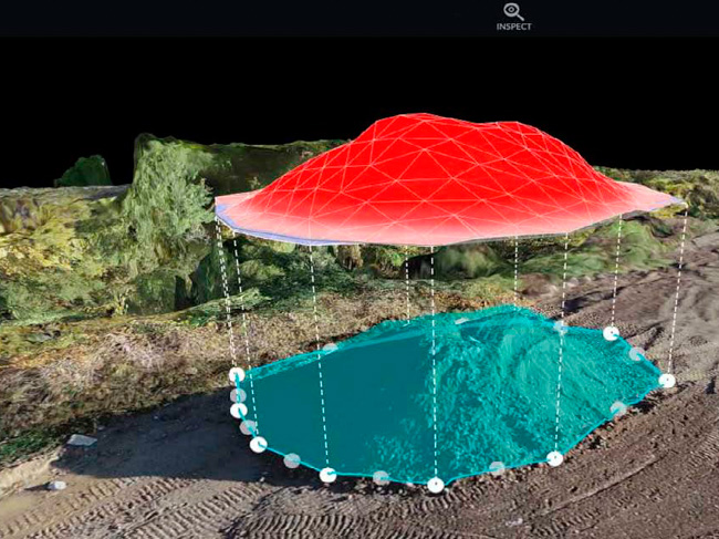
Construction technology has revolutionized the way projects are managed and executed. One company at the forefront of this revolution is Drone Brothers, a leading provider of aerial photography and videography, mapping data, and analytics. However, we also provide large-format printed orthomosaic maps for construction clients. These maps play a vital role in keeping track of construction progress and facilitating effective coordination among teams.
The Value of Tangible Tools
While Drone Brothers recognizes the power of digital maps, we also understand the importance of tangible tools in the construction industry. To bridge the gap between high-tech and low-tech, Drone Brothers offers large-format printed maps of construction sites.
Measuring an impressive 20 inches by 30 inches, these printed maps boast high resolution and exceptional clarity. The larger size is favored by project managers and superintendents, as it allows for easier visualization and interpretation of construction progress. These maps are strategically hung both inside and outside of construction trailers, serving as a constant visual reminder of the project’s status.
Enhancing Communication and Collaboration
The printed maps provided by Drone Brothers play a pivotal role in fostering effective communication and collaboration on construction sites. They serve as crucial visual aids during team huddles, meetings, and discussions, allowing participants to have a clear understanding of the work being done and the progress that has been made.
Project managers and superintendents can easily point out specific areas on the maps, providing visual context for their instructions and ensuring that everyone is on the same page. This seamless integration of high-tech digital maps and low-tech printed maps facilitates efficient coordination and planning, ultimately leading to improved productivity and project success.
The Unique Value Proposition
Drone Brothers takes immense pride in offering both electronic and printed maps to their construction clients. By doing so, we address the diverse needs and preferences of their customers, while also maximizing the benefits of mapping technology solutions.
Conclusion
Staying up to date with the latest technology is crucial in construction. Drone Brothers understands this, and we have successfully bridged the gap between high-tech and low-tech in construction mapping. By providing digital 3D orthomosaic maps alongside large-format printed maps, we offer a comprehensive solution that meets the diverse needs of our construction clients.
Through our innovative approach, Drone Brothers helps clients save time and money, and increase safety on construction sites. The digital maps provide real-time information and facilitate effective decision-making, while the printed maps enhance communication and collaboration among teams.
As the construction industry continues to evolve, Drone Brothers remains at the forefront, constantly redefining what is possible in construction technology. Our commitment to providing valuable solutions and their seamless integration of high-tech and low-tech tools make them a trusted partner for construction projects of all sizes. With Drone Brothers, construction mapping has never been more powerful or accessible.
0 Comments